El Nino and La Nina
What are El Nino and La Nina?
- El Nino - (El Nee-nyo) is the warming of water in the Pacific Ocean.
- La Nina - (Lah Nee-Nyah) is the cooling of water in the Pacific Ocean.
|  |
| El Nino Weather | La Nina Weather |
| | - Snow and rain on the west coast
- Unusually cold weather in Alaska
- Unusually warm weather in the rest of the USA
- Drought in the southwest
- Higher than normal number of hurricanes in the Atlantic
|
| Satellite Image of El Nino |
|
 |
| Years of El Nino |
| 1902-1903 | 1905-1906 | 1911-1912 | 1914-1915 |
| 1918-1919 | 1923-1924 | 1925-1926 | 1930-1931 |
| 1932-1933 | 1939-1940 | 1941-1942 | 1951-1952 |
| 1953-1954 | 1957-1958 | 1965-1966 | 1969-1970 |
| 1972-1973 | 1976-1977 | 1982-1983 | 1986-1987 |
| 1991-1992 | 1994-1995 | 1997-1998 | ???? |
|
|
| Satellite Image of La Nina |
|
 |
| Years of La Nina |
| 1904-1905 | 1909-1910 | 1910-1911 | 1915-1916 |
| 1917-1918 | 1924-1925 | 1928-1929 | 1938-1939 |
| 1950-1951 | 1955-1956 | 1956-1957 | 1964-1965 |
| 1970-1971 | 1971-1972 | 1973-1974 | 1975-1976 |
| 1988-1989 | 1995-1996 | 1998-1999 | ???? |
|
|
Interesting Facts
- El Nino was first discovered hundreds of years ago by fishermen off the coast of Peru.
- El Nino means "Little Boy" and was named after the Christ child, because it usually starts around Christmas.
- El Nino is officially called ENSO - El Nino Southern Oscillation.
- La Nina means "Little Girl." It is also called El Viejo, which means "old man," or an ENSO cold event.
- La Nina occurs roughly half as often as El Nino
- El Nino and La Nina are the most powerful phenomenon on the earth and alter the climate across more than half the planet.
- El Nino may be caused by underwater volcanoes in the Pacific.
El Niño and La Niña: Weather's Sibling Rivalry
Just when you think you've got the seasons in your area all figured out, along comes a winter that is nothing like what you expect. Around the country, around the world, everything seems to be upside down. Places like Seattle that are accustomed to cool temperatures and a lot of rain instead get warm, dry weather. Places like sunny southern California, the Southwest desert, and even the southeastern United States get cold temperatures and heavy rain. In the usually cold Northeast, it doesn't even feel like winter. And it snows in weird places like in Guadalajara, Mexico.
That's almost a sure sign of El Niño — above-average Pacific Ocean sea surface temperatures and atmospheric conditions that change the places where storms go.
Cold temperatures and rain befall the usually dry deserts, and warm dryness comes to the usually cool forests of North America, South America, and much of the rest of the world. The important thing is not that there is more hard winter weather around the world during El Niño — although during a big El Niño, a grande El Niño, there certainly seem to be more storms. El Niño's "Bad Boy" reputation as a natural disaster comes not from extra storminess, but from the fact that it puts storms in places that can't handle them so well.
Is El Niño a bad boy?
Is El Niño really bad news? It all depends on where you live. A powerful El Niño is terrible news to people in Ecuador and Peru, for example, who often face deadly floods in their steep desert terrain. It's not much good to southern California either, and for the same reason — the desert soil can't absorb much water, so the rains bring on floods and mud slides. But the folks in Seattle and western Canada don't mind a mild winter once in a while. In the northeastern United States, often El Niño means milder winter temperatures and less snow than usual — less hardship and a welcome savings on winter heating bills. And for people across the Gulf States and the Eastern Seaboard, El Niño does one really good thing in the Atlantic Ocean in the summer and fall. It generates powerful high-altitude winds that cut the tops off of tropical storms before they can grow into hurricanes.
Good or bad, scientists say that, aside from the seasons themselves, El Niño is the most powerful climate force on Earth. So this is a big part of the big answer to the little question: Why is one winter different from another? It's not the only reason, of course. But if one winter is very different from normal — almost the opposite of what you would expect — take a look out in the tropical Pacific Ocean.
The El Niño look
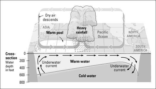
If El Niño is out there, as it is in Figure 1, the Pacific Ocean has a very different look. The Warm Pool and the big thunderstorms have moved. Instead of up against south Asia, they are spread out into the middle of the Pacific or even far over on the other side of the ocean, up against the coast of South America. All kinds of big changes are taking place. The tradewinds have completely pooped out and may even be blowing in the opposite direction. The Cold Tongue is a goner, and in its place is extra-warm water. Take a look at the jet stream, the storm track. Instead of looping around like it normally does, it is so strong that it carries storms straight over the Pacific Ocean and across the Southwest and the southern United States.
Figure 1: Features of El Niño across the tropical Pacific.
These important season-changing conditions — the Warm Pool and the big thunderstorms and the winds — seem to swing back and forth from one extreme to another across the tropical Pacific Ocean. On average, every three to seven years El Niño seems to come along. But "average" and "normal" are not very good words to use with things like El Niño. Like a lot of things about weather, "average" and "normal" don't seem to come around very often. The swings from especially warm to especially cool Pacific Ocean conditions are not regular, and their pattern is not reliable.
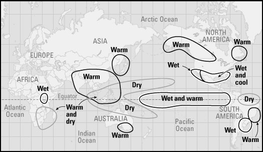
Some climate experts at the Go Figure Academy of Sciences and elsewhere have been trying to make a computer model that acts like the Pacific Ocean, swinging between warm and cool, so that they can predict when El Niño will show his face. But they're not very good at it yet. On the other hand, scientists have become very good at using new tools like satellites and buoys moored across the ocean to detect changes in the temperature of the water and in the winds. So once El Niño conditions begin to take shape, they can see them sooner. If you live in a region that feels El Niño's effects, this means that some years climate experts may be able to warn you months in advance about what kind of winter to expect. Figure 2 shows the patterns of global weather that are linked to a powerful El Niño.
Figure 2: Common winter weather impacts of El Niño.
La Niña, the contrary sister
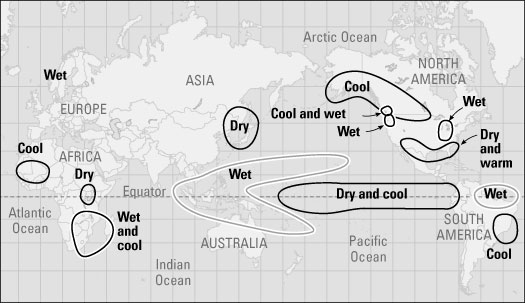
El Niño causes some serious weather problems around the world, no doubt about it, but La Niña, which Figure 3 illustrates, is not exactly a sweet little thing either. In places like the northeastern United States that are accustomed to cold and snowy winters, La Niña often makes for especially hard winters. In the rainy Pacific Northwest, La Niña winters seem to bring even more rain and snow than usual.
Figure 3: Features of La Niña across the tropical Pacific.
Across the desert Southwest, often the season is even drier than normal. Tornadoes seem especially numerous during springs and summers of La Niña, and the Atlantic hurricane season can be especially long and dangerous. In 1999, for example, while La Niña conditions prevailed in the tropical Pacific Ocean, 12 tropical storms grew big enough to earn names, eight of them became hurricanes, and five became intense hurricanes.
Here is a rule that is not always exactly true, but still is useful to compare the impacts of El Niño and his contrary sister. Where El Niño is warm, La Niña is cool. Where El Niño is wet, La Niña is dry. While El Niño conditions and their seasonal impacts look very different from normal, La Niña conditions often bring winters that are typical — only more so. There's something else to keep in mind: El Niño and La Niña tend to make seasonal conditions one way or another, but every El Niño and La Niña is different.
The La Niña look
Like a lot of brothers and sisters, El Niño and La Niña don't get along together. In the tropical Pacific Ocean, they are opposites. If you have one, you can't have the other. In the ocean, the uppermost layer of warm water — which flattens out during El Niño — now has an especially sharp wedge-shape to itself during La Niña. It is thick up against South Asia, where the Warm Pool is especially deep. Above the ocean, the tradewinds are especially strong. And on the opposite side of the ocean, up against South America, because of the strong offshore winds, the warm surface layer disappears altogether. The deeper cold water is flowing directly up to the surface for a great distance along the Equator. This means that the Cold Tongue is sticking out far into the sea.
La Niña impacts on the world's weather are less predictable than the effects wrought by El Niño. This is mainly because of the big differences in the jet stream and the storm track. El Niño causes the Pacific storm track to become stronger, to drop farther south than usual, and to straighten out like a necklace of weather extending more-or-less straight across the ocean. The La Niña storm track is weaker and loopy and irregular, like a piece of wet and wiggly spaghetti, more changeable — so the behavior and direction of the storms it carries are more difficult to accurately forecast (see Figure 4).
Figure 4: Common winter weather impacts of El Niño. http://as.dummies.com/how-to/content/el-nino-and-la-nina-weathers-sibling-rivalry.html
Typhoons in the Philippines
Typhoons in the Philippines and affect the describes the most notable tropical cyclones to enter the Philippine Area of ResponsibilityPhilippines. Bagyo is a term referring to any tropical cyclone in the Philippine Islands.An average of 6 to 7 tropical cyclones hit the Philippines per year
A bagyo is categorized into four types according to its wind speed by the PAGASA. All tropical cyclones, regardless of strength, are named by PAGASA. Tropical depressions have maximum sustained winds of between 55 kilometres per hour (30 kn) and 64 kilometres per hour (35 kn) near its center. Tropical storms have maximum sustained winds of 65 kilometres per hour (35 kn) and 119 kilometres per hour (64 kn). Typhoons achieve maximum sustained winds of 120 kilometres per hour (65 kn) to 185 kilometres per hour (100 kn)
with super typhoons having maximum winds exceeding 185 kilometres per hour (100 kn).
The most destructive tropical cyclone to impact the Philippines was Tropical Storm Thelma in 1991, which killed thousands of people from its resultant flooding.
The wettest known tropical cyclone to impact the archipelago was the July 1911 cyclone which dropped over 1,168 millimetres (46.0 in) of rainfall within a 24 hour period at Baguio CityAt least 30 percent of the annual rainfall in the northern Philippines could be traced to tropical cyclones, while the southern islands receive less than 10 percent of their annual rainfall from tropical cyclones.
Most destructive

Thelma approaching the Philippines
| Most destructive typhoons in the Philippines |
| Rank | Storm | Dates of impact | Deaths | Damage |
| 1 | Thelma/Uring 1991 | November 2-7 , 1991 | 5,101-8,000[6] | P 1.045 B |
| 2 | Angela/Rosing 1995 | October 30-November 4, 1995 | 936 | P 10.829 B |
| 3 | Mike/Ruping 1990 | November 10-14, 1990 | 748 | P 10.846 B |
| 4 | Joan/Sening 1970 | October 11-15, 1970 | 768 | P 1.89 B |
| 5 | Agnes/Undang 1984 | November 3-6, 1984 | 895 | P 1.9 B |
| 6 | Babs/Loleng 1998 | October 15-24 1998 | 303 | P 6.787 B |
| 7 | Nina/Sisang 1987 | November 23-27, 1987 | 979 | P 1.119 B |
| 8 | Flo/Kadiang 1993 | September 30-October 7, 1993 | 576 | P 8.752 B |
| 9 | Amy 1951 | December 6-19, 1951 | 991 | P 0.7 B[13] |
Wettest recorded tropical cyclones
http://en.wikipedia.org/wiki/Typhoons_in_the_Philippines


No comments:
Post a Comment